Introduction
By comparing John Christopher's text with maps, I have charted what I believe is the likeliest route Will, Henry, and Beanpole take to the White Mountains.
The end of their journey, specifically, is the Jungfrau Railway Tunnel, which is a real location. The Swiss built this tunnel in 1912 to transport people by rail up to the Jungfraujoch.
Throughout this essay, I talk about the route I have mapped, and about various fictional locations, as if they were canon, but I only do so for the sake of ease. They are still merely my opinion.
I refer to Will, Henry, and Beanpole as the trio because, again, it makes things much easier.
I live in the United States and have never been to Europe. I used nothing but on-line maps, my best reasoning, and my best guesses to chart this journey. All distances are approximate, but I got them using the scales of those on-line maps, so they should be close to accurate.
Each map on this page is a thumbnail.
Wherton
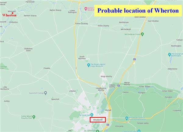
Wherton does not exist in real life, but it is near the city of Winchester, which does. Winchester is in the far south of England.
Jack tells Will that when he visited his aunt on the other side of Winchester, he went for a walk one day and came to the sea. This means the sea is on the other side of Winchester from Wherton, which means Wherton is somewhere north of Winchester.
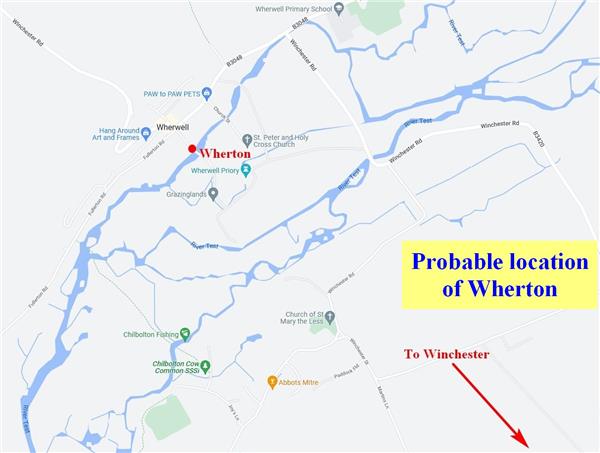
Wherton is on a river.
I found a real town northwest of Winchester called Wherwell, near the Test River. Since Wherwell and Wherton have the same first syllable, I chose this location for Wherton.
This places Wherton about 9 miles from Winchester.
 |
 |
The entire route
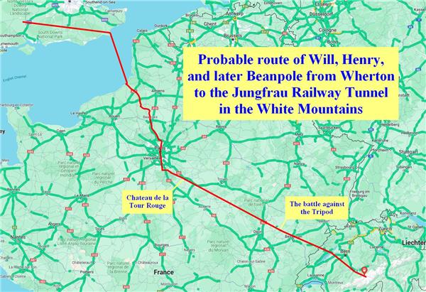
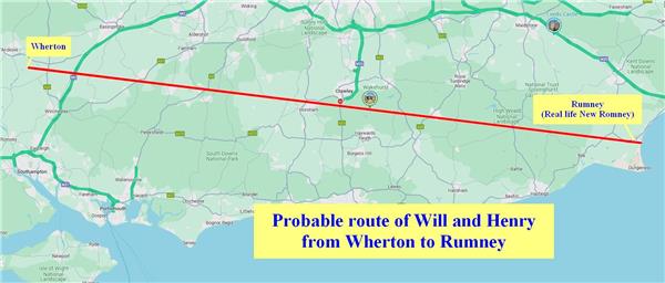
Here is the entire route, which stretches 597 miles. Below, I break this route into sections to explain my choices.
From Wherton to Rumney
110 miles
Ozymandias tells Will he'll find Captain Curtis in Rumney. This is a fictional town, but there is a real town on the east coast called New Romney. Because of this similarity, I decided that New Romney is the location of Rumney.
Also, Wherton is only 21 miles from the south coast, but Will and Henry travel for many days before coming to Rumney (even taking into account the time they rest for Will's ankle to heal). Traveling that length of time before reaching the sea can only mean they're going east.
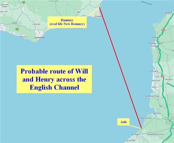
Across the English Channel
61 miles
The route Captain Curtis takes across the English Channel is south-southeast. I base this assertion on two things:
First, the Orion's channel crossing takes at least a full day. If the Orion were to take the shortest distance to France, which is almost due east, it would only take a few hours.
Second, John Christopher's description of the trio's journey from the coast of France to Paris makes it clear that Will and Henry arrive in France no more than 100 miles from Paris, which means Captain Curtis takes them far south before bringing them in to land. And this is the logical thing for Captain Curtis to do. To give Will and Henry all the help he can, he would take them as far south, and as far east, as possible.
I chose the town of Ault as the place Captain Curtis drops off Will and Henry, for two reasons. First, this is the closest Captain Curtis can get Will and Henry to the White Mountains, because beyond Ault the coastline bends back to the west. Second, it sets up the train ride perfectly, which I explain in the next section.
From the French coast to the end of the train ride
79 miles
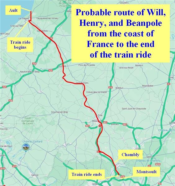
Beanpole leads Will and Henry south, then leads them west to hop on a train. The journey from the coast to the train takes less than a day.
The train travels more than 50 miles but fewer than 100, to the southeast.
The trio get off the train just before it reaches a large town. The next morning, they come over a hill and get their first sight of Paris, so it's clear the train took them almost all the way to Paris.
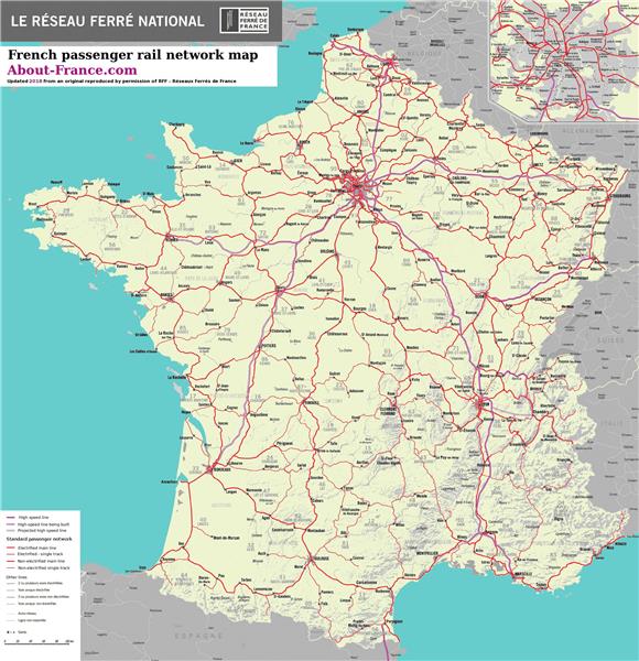
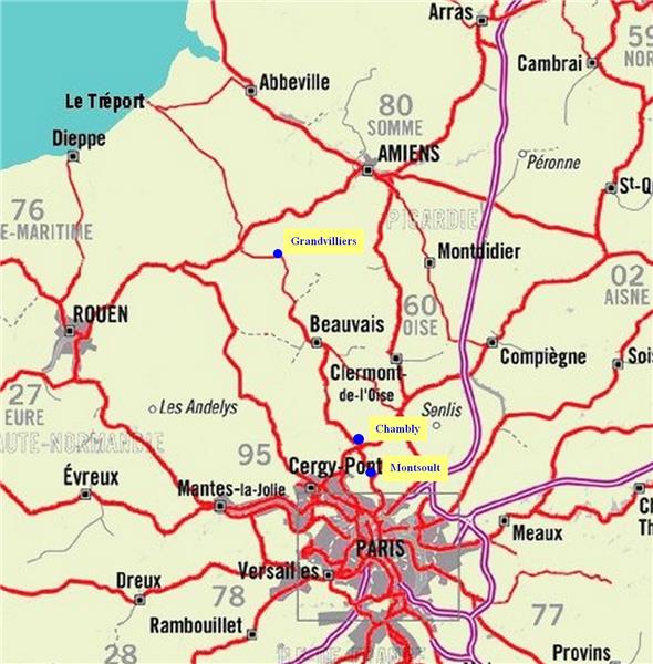
I found a map of France's passenger railways (the few freight railways I found weren't relevant). I provide this map below, plus an edited section which shows a bit more detail. The best railway journey I can see which fits John Christopher's description is the line from Le Treport through Grandvilliers, Beauvais, and Chambly.
The fact that the train starts in or near Le Treport is the second reason I chose Ault as the town in which Will and Henry come ashore (see the previous section). Ault's location allows Beanpole to lead them south, then west, to catch the train, as John Christopher describes.
No town which the railway goes through just north of Paris seems larger than any other, so it's not clear which town was so large that it prompted the trio to get off the train. Therefore, I made a rough guess simply by eyeballing the distance on the map. I decided that the town in question is Montsoult. A mile north of Montsoult seems to be just outside the contiguous urban area surrounding Paris, and seems just close enough that the trio would see Paris laid out before them reasonably well.
The distance the trio travel by train is about 75 miles, which fits John Christopher's description nicely. The distance from the coast to the train is an additional four miles, for a total of 79 miles.
Bonus trivia (for those, like me, who don't speak French): When Will hears Shmand-Fair, he is hearing the phrase chemin de fer. Its literal translation is road of iron, but its true translation is railroad.
 |
 |
 |
Paris and the Seine
Northwest of Paris, the Seine winds back and forth significantly several times. South and east of the center of Paris, the Seine extends south for a while before turning back to the southeast. I bring this up because a person traversing Paris, depending on their route, could easily need to cross the Seine multiple times.
The trio cross the Seine near Notre Dame cathedral in the center of Paris (see below). It's possible the trio cross the Seine multiple times, but one would think John Christopher would mention this. Therefore, I assume they only cross it once, and I feel pretty confident in this assumption. This assumption significantly affects my choice of their route through Paris. The route isn't entirely logical for several reasons (i.e., the trio might have made better choices), but it matches the novel's text.
First, the trio could have bypassed Paris entirely. Once they hopped off the train, if they had followed the compass east-southeast directly towards the White Mountains, they actually never would have entered the city, and they never would have had to cross the Seine. Their route would have cut much more closely to the present-day location of Disneyland Paris. However, I understand why John Christopher had them traverse Paris for narrative reasons, so this is not a criticism, merely an observation. One can rationalize the trio's decision to traverse Paris by saying that doing so helped them avoid people and Tripods for many miles.
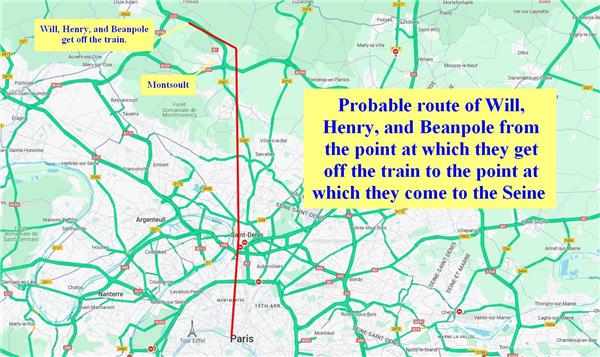
Second, my assumption that the trio only cross the Seine once, in the center of Paris, means their route through Paris is almost due south the entire way. There's no avoiding this, as the Seine would be in their way at least one more time on any other route. Please notice that on the route I chose, they come extremely close to the Seine in the northern part of Paris, in Saint-Denis, and extremely close again in the southern part of Paris, near Savigny-sur-Orge. These two points dictate the route; the trio have to pass both without crossing the river another time.
I map the trio's route through Paris in a straight line, even though obviously it isn't straight because they walk down city streets. My map of their route through the city is a rough approximation.
From the end of the train ride to the Seine
18 miles
After getting off the train, the trio hike south into Paris. John Christopher doesn't say they go east-southeast before going south, but I route them around Montsoult since the trio avoid populated areas. Also, having them go east-southeast before turning south gets them around that point in Saint-Denis where the Seine would otherwise have gotten in their way.
Crossing the Seine
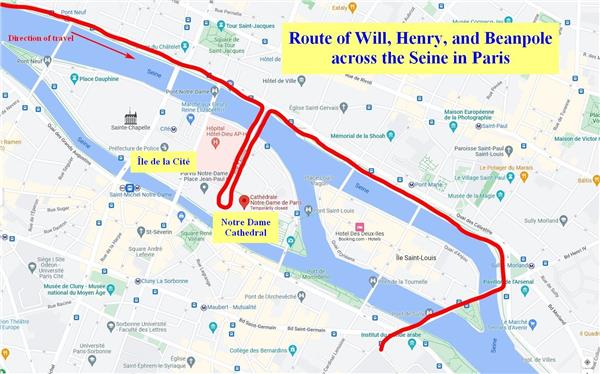
This part was the easiest to map because John Christopher's description is precise. While not naming any place explicitly, his description makes it clear that the trio try to cross the Seine by Notre Dame Cathedral, but have to turn back because there's no southern bridge.
The journey depicted on the map below is 1.5 miles, but it's so short that I don't include this in the total distance.
Bonus thought: I wonder if the Eiffel Tower fell during humanity's war against the Masters. It's clearly visible from almost anywhere in Paris and is visually striking, with nothing else tall around it, and the trio is only two miles from it when they cross the Seine. I'm certain Will would describe it in his narration, or the trio would marvel at it. But they never mention it, and from all the damage they see, it's clear Paris was a major battle site against the Tripods.
The Chateau de la Tour Rouge
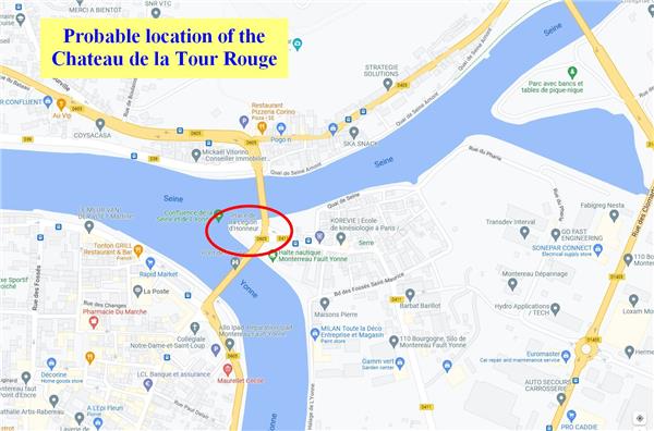
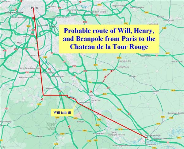
The Chateau de la Tour Rouge is near Paris, as the trio arrive at the chateau only a few days after leaving Paris. The chateau is a grand building at the confluence of two rivers.
I find only two locations which fit this description, and they're near each other.
The one I like least is the confluence of the Seine and the Canal du Loing in Saint-Mammes. The canal is wide and the characters might mistake it for a river, or they might not.
The other location, which I firmly believe to be the correct one, is the Place de La Legion d'Honneur in Montereau, at the confluence of the Seine and the Yonne. It just looks like a place someone would build a castle.
Will and Eloise row a boat to an island one day to have a picnic. Each location has at least one island nearby, so no problem there.
From the center of Paris to the Chateau de la Tour Rouge
50 miles
Assuming the trio only cross the Seine once, they must travel almost due south, at least as far as that point near Savigny-sur-Orge where the Seine comes back to the west before turning southeast. I route them some ways past this point, since I get the feeling the trio don't really change their direction until they travel significantly past the city and back into open countryside.
The map from Ozymandias instructs the trio to find a wide river south of Paris, and to follow this river to the southeast. Ironically, this can only be the Seine, which they find the day after leaving Paris. The day after that, Will becomes too ill to travel, so they don't follow the river very long.
After leaving the Chateau de la Tour Rouge
After the trio leave the Chateau de la Tour Rouge, their journey is a straight shot east-southeast all the way to the Jungfrau Railway Tunnel.
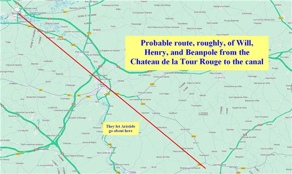
From the Chateau de la Tour Rouge to the canal
41 miles
After leaving the Chateau de la Tour Rouge, the trio come to a place John Christopher describes so specifically that I have to wonder if he was looking at real places on the map when writing The White Mountains. If so, I further wonder if I found the same place he did.
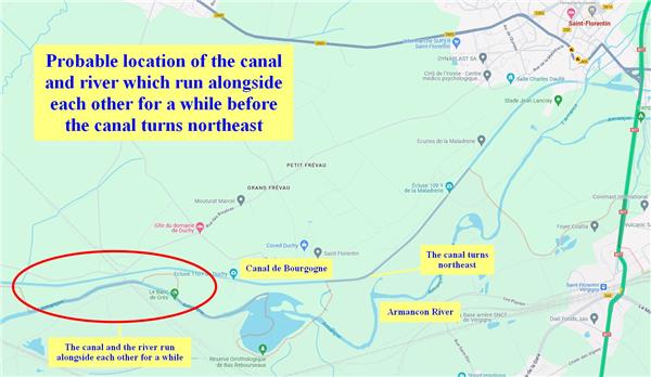
John Christopher describes a river and a canal running parallel close to each other for a while, with the canal being above (north of) the river. The trio call the canal a straight-river, and Beanpole tries to convince Will and Henry that the ancients built it. The trio follow the canal for a while, but they leave it when it cuts sharply north.
There is a real location along the trio's route, at the exact point it needs to be, which matches this description. Just southwest of Saint-Florentin is an area in which the Canal de Bourgogne and the Armancon River run closely alongside each other, with the canal north of the river. Then the canal turns northeast toward Saint-Florentin.
The only discrepancy is that John Christopher says, "Where the straight-river turned sharply back on itself, to the north, we left it." The Canal de Bourgogne's northward turn is a 45-degree bend to the northeast, hardly a sharp turn back on itself to the north, but this may just be a matter of semantics. The location matches John Christopher's description in all other aspects to a remarkable degree.
 |
 |
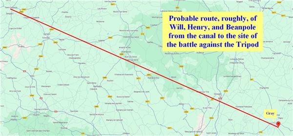
From the canal to the site of the battle against the Tripod
110 miles
By far, this part of the journey requires the most guesswork, and is the most approximate.
Some time during the two days after the trio leave the canal, they swim across a river in a broad valley. They're so exhausted after swimming the river that they rest for a while.
This river can only be the Armancon. But it roughly parallels the trio's route for so long, it twists and turns so much, and John Christopher's description of the elapsed time is so vague, that I don't want to try to pin down the location of this crossing.
To find the location of their battle against the Tripod, I analyzed the amount of time which passes after they leave the canal.
The trio fight the Tripod seven days after leaving the canal. Possibly six days, as John Christopher's description at the beginning is a little vague, but I think it's seven.
A person can walk about twenty miles a day at a normal pace, so I assume the trio cover this distance in a normal day. However, the more time it takes to forage for food or to steal food, the less distance the trio travel on a given day.
The following table shows the passage of time from leaving the canal to fighting the Tripod, and my rough guesses about the distance they travel. A day number refers to the days after leaving the canal.
Day 0 is the day they leave the canal. I assume this happens halfway through the day, so the distance they travel away from the canal during the second half of that day would be half the usual, which is ten miles.
| Day | Miles | Events and analyses |
|---|---|---|
| 0 | 10 | They still have food, so they walk ten miles for the second half of the day. |
| 1 | 20 | They still have food, so they walk 20 miles. They reach the valley. |
| 2 | 10 | They cross the river, rest a while, and raid a farm house, even taking time to eat a meal inside the house. So they only walk 10 miles. |
| 3 | 15 | They finish all the food from the farm house. They try to eat some grapes which aren't ripe, then sleep in a hut. They only walk 15 miles because they have to forage for food. |
| 4 | 15 | They realize the Tripod is following them. I presume they spend part of the day foraging because they have no food (John Christopher doesn't say), so they walk only 15 miles. They sleep in a ditch. |
| 5 | 15 | They collect a lot of turnips, enter a forest, and end their day a little early because they find a hut. They eat a rabbit. Because they end their day early and forage for food, they only walk 15 miles. |
| 6 | 15 | They eat berries and fill their sacks with potatoes. They catch their first sight of the mountains, then sleep in a pine forest. Because they forage for berries and potatoes, they only walk 15 miles. |
| 7 | 10 | They set a faster pace than usual, but they also go west for a bit to search for a river on the map. The fact that they go west for a little while strongly detracts from the 20-mile-per-day progress they could make. Also, they find some wild horseradish, which means they spend part of their day foraging. And, of course, they take time to cut the tracking device out of Will. They fight the Tripod at sunset, so at least they walk the entire day. I call it ten miles of total progress. |
This is 110 miles, which places the battle site just southeast of Gray, France. The river they try to find on their map could be the Saone, or any number of little rivers around there.
From the site of the battle against the Tripod to the Jungfrau Railway Tunnel
128 miles
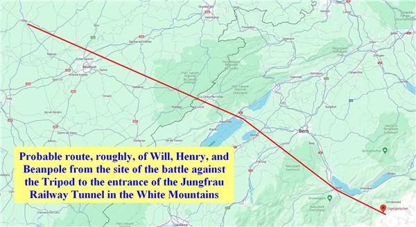
John Christopher's description of this leg of the trio's journey is too vague to determine the site at which two Tripods walk past them while playing with a glowing ball.
As best I can tell, the Jungfrau Railway enters the tunnel shortly after Eigergletscher Station, and I believe this tunnel entrance is the trio's destination.
There's nothing remarkable about this leg of the journey except that the trio have to jag a little to avoid falling into one of those big lakes.
